
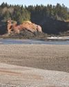
For several years,I’d heard Quebec’s Gaspé Peninsula described with glowing superlatives. It was often referred to as “the Canadian version of California’s Highway 1” with its majestic views. So when I was invited to accompany my friend Janet to visit it, I had to see if such accolades were accurate.
We spent the majority of our trip driving— our yellow Beetle covered more than 1,700 kilometres in ten days. Route 132 through the region, known as the BasSaint-Laurent, outlines the Gaspé Peninsula. Along the north shore, the highway soars to celestial heights before dipping into deep bays, then out onto windswept capes. Dominated by the Chic-Choc Mountains, forest covered hills are ablaze with colour in the fall.
The majority of the population lives along the lengthy coastline, and most of the towns have their own picturesque features, whether it is a museum, lighthouse or a quaint fishing harbour.
The Gaspé Peninsula, while appearing no larger than a thumbnail on the Canadian map, is actually larger than Belgium. It’s bordered on the north by the immense flowing ribbon of the St. Lawrence River, and on the south side by the Gulf of St. Lawrence, which empties its steel-blue expansiveness into the Atlantic Ocean. As far as the eye can see, sky and sea merge like a faint watercolour. Viewing it was a humbling experience, filling me with a feeling of isolation and solitude.
This story is from the November 2018 edition of More of Our Canada.
Start your 7-day Magzter GOLD free trial to access thousands of curated premium stories, and 9,000+ magazines and newspapers.
Already a subscriber ? Sign In
This story is from the November 2018 edition of More of Our Canada.
Start your 7-day Magzter GOLD free trial to access thousands of curated premium stories, and 9,000+ magazines and newspapers.
Already a subscriber? Sign In
Welcome to St. Martins
Jane LeBlanc takes us on a tour of her adopted hometown—this charming New Brunswick village on the beautiful Bay of Fundy

Flower Power
Discovering a hobby you’re passionate about keeps you young!
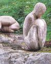
HIKING THE HALIBURTON HIGHLANDS
Admiring sculptures, Inuksuks and a view of the falls is all part of the allure of this area
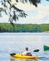
Distanced But Not Alone
Last summer’s ‘Fun Day’ at Otter Lake became a message of hope
CAJUN COUNTRY
Exploring the complex history and amazing culture of Acadians in Louisiana

Nature's Wonder
Having the opportunity to photograph local wildlife is a gift

A Pinch of Slowness
Taking the time to enjoy the process is a great recipe for bread—and life

CREATIVITY DURING COVID
How I ‘brought a young girl to life’ during quarantine
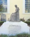
A Pivotal Point
From early settlement and quaint village to prosperous town and city, Pointe Claire is rich in Canadian history

A Dream Car Finds Its Dreamer
Imagine finding the car you loved as a teen parked in your driveway 25 years later