Intentar ORO - Gratis
Two Nations, Two Destinies
Outlook
|September 21, 2024
The widely differing balance of power between the military and civilian leadership in India and Pakistan has significantly impacted democracy in the two countries
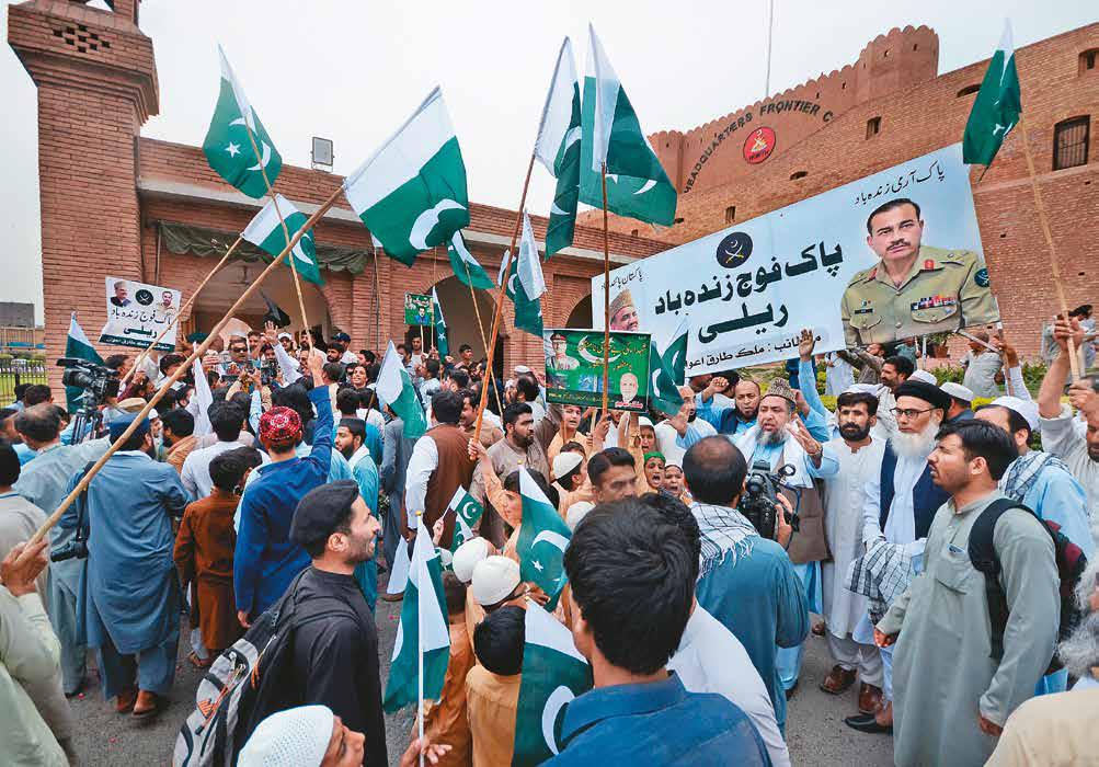
HAVE there been times when civil-military relations in India were so strained that a military coup was -justified? asks Aditya Sondhi, a senior advocate practising at the Supreme Court and the Karnataka High Court, in his new book Poles Apart: The Military and Democracy in India and Pakistan. Sondhi's book is a timely addition to the existing literature on civil-military relations in South Asia. It compares the roles the military has played in India and Pakistan and their impact on the arc of democracy in both countries. It also devotes a chapter to Bangladesh currently in the grip of a historic political churning-and the country's tryst with both democracy and military rule. Poles Apart evolved from Sondhi's research for his PhD thesis, which focused on the interface between the military and democracy in India and Pakistan during 1947-2008. The road from thesis to book was paved with revisions, updates, and a chapter on post-2008 developments.
Some of the pertinent questions Poles Apart raises and investigates are: Is there a connection between the "non-event" of a coup and the growth of democracy? Why has Pakistan been under military rule for long periods and how has this affected the survival of democracy? How did the Pakistani military get actively involved in politics and why does it wield so much influence in the country’s political space?
In the book’s well-crafted Introduction, Sondhi reminds readers that democracy is a complex business and nation states, unique. In this context, comparative politics may be a “theory in transition”, but it definitely has its uses. An analysis of similar institutions in India and Pakistan such as the judiciary, the bureaucracy, political parties, the electoral process, the culture and belief systems, and the role of the military and the extent of its intervention helps to gauge the “health of democracy” in the two countries.
Esta historia es de la edición September 21, 2024 de Outlook.
Suscríbete a Magzter GOLD para acceder a miles de historias premium seleccionadas y a más de 9000 revistas y periódicos.
¿Ya eres suscriptor? Iniciar sesión
MÁS HISTORIAS DE Outlook

Outlook
Scaling New Heights
A remarkable journey of an illustrious personality from policy corridors to corporate strategy
2 mins
October 11, 2025

Outlook
Shaping Futures in the North East
A Visionary educator, Prof (Dr) Sangeeta Tripathi, contributing significantly to the development of education in the North- East of India
2 mins
October 11, 2025

Outlook
Driving The Royal Enfield Phenomenon
Think of motorcycles in India and you will think of Siddhartha Lal. Lal stands out as a trendsetter who has without exaggeration redefined the industry landscape. As the driving force behind Royal Enfield's global resurgence.
2 mins
October 11, 2025

Outlook
Designing Impact
Cultural ambassador and economic powerhouse, eminent designer Sabyasachi Mukherjee is an unusual visionary of India's $5 trillion economy ambition
2 mins
October 11, 2025

Outlook
Bridging Innovation and Impact in Global Agriculture
HarvestPlus Solutions supporting India's present through sustainable innovation and sowing the seeds of a healthier, more resilient, and truly Viksit Bharat
2 mins
October 11, 2025

Outlook
The Face of New-Age Leadership
Mahesh Patil, transforming a single entity into a diversified, resilient, and internationally minded conglomerate, shares his vision on career-making in today's global and interconnected workspace in conversation with Aditi Chakraborty
4 mins
October 11, 2025

Outlook
Preserving Freshness Extending Shelf Life
By championing product safety and shelf life through active packaging innovations, Manish Jain is redefining India's role in global healthcare and food systems
2 mins
October 11, 2025
Outlook
Languishing in Loneliness
How do people deal with the unbearable emptiness of being when the system commodifies everything. including love, sex and companionship
8 mins
October 11, 2025

Outlook
Paving the Future Path
Visionary leader Ashok Kheny pioneering progressive transformation by building award-winning roads, corporate hubs, and sustainable townships for a prosperous and futuristic Bangalore
2 mins
October 11, 2025

Outlook
Pioneering the Fusion of Tradition and Luxury in India's Fashion Renaissance
Redefining Indian fashion by intertwining Bollywood glamour with indigenous crafts, inspiring a legacy of cultural preservation and entrepreneurial vision
2 mins
October 11, 2025
Listen
Translate
Change font size